Thursday 15 January 2015

DAY 18 - Monday / Surf Hostel, Bundoran, Donegal - Sligo - Donegal - Enniskillen Fermanagh - Ferry Terminal 2, Dublin - Ferry Terminal at Dún Laoghaire, Dublin / Road 220 miles - Ferry 68 miles - Road 248 miles


04/08/2014 / Monday / Surf Hostel, Bundoran, Donegal - Sligo - Donegal - Enniskillen Fermanagh - Ferry Terminal 2, Dublin - Ferry Terminal at Dún Laoghaire, Dublin / Road 220 miles - Ferry 68 miles - Road 248 miles

Monday and my travelling back home day.

Today didn't start off so well, I really should have taken the opportunity of gotten fuel the night before. All fuel stations this morning are closed till 8am, leaving me having to back track to Sligo to find an Esso with a pay by card pump, which I only discover, after having sat right next to it, waiting for the garage to open, do I happened to look down and read the white writing on the floor which says the magic words 'Pay At Pump', what an idiot!

The only trouble with the pay as you go pumps, is the fact that you have to firstly tell the machine exactly how much you need. Now I had some fuel already in my 15 litre tank, but I wasn’t sure how much I needed to brim it. So thinking ahead I put only 5 litres in, then by the time the petrol station are open, and I'm further down the road, I can then fill up again in the usual way.

From Sligo, I follow the N15 to Donegal, midway stopping to finally brim the tank up. But as I pull up to the pump, and got off, I promptly lose all sense of balance and the bike falls against the pumps. I managed to lift it away, without damaging anything, but clearly I hadn’t woken up yet.  After fuelling up, I parked the bike next to the shop and pop in to pay and grab a coffee, taking 10 minutes to get my head straight. In that time I watch a middle aged man I had spotted, walking along the road dressed in a wool suit, walk passed on his way to the nearest town and it occurred to me, how little you see people just walking to their destination, rather than driving or using other forms of transport nowadays.

Feeling more awake I soon blast up to Donegal and complete my circuit of Ireland, tooting my horn in a small personal triumph, before stopping to punch in my final waypoint, Ferry Terminal 2 Dublin into the Satnav. 

Fig. 1 - The A46, a gorgeous road on a sunny day.
The Satnav backtracks me South back along the N15 to then turn East onto the N3, which became the A46, as I cross over the border into the North of Ireland, a beautiful road leading into Enniskillen. I stopped to take a quick photo, of the now open Hostel and the street where my new friend Malina lives. I would have phoned her up if I had her number but I would of risked losing the morning, instead of making tracks.

The ride to Dublin at full pelt was tough going as I knew I'd miss my boat, but I arrived at T2 hoping to get on the next available one home. Luckily because I was late they sent me down to Dun Laoghaire, to catch the next high speed crossing but warning me that there would be a small fee. I arrived in reasonable time with 10 to 15 minutes to spare, I didn’t mention the fee and luckily, neither did they.


I boarded, this time without making any new friends and as I knew the drill on this type of boat, I quickly went to the loo and made my way to the restaurant, getting some food before the rush and then found a comfy seat at the back, near the open doors to stay cool and catch a snooze.

As I was eating in the restaurant the TV was on giving me surround sound news 24 which I didn’t wish to see, dragging me back to the everyday, it’s nice, not to be in the loop.

I arrive at Holyhead and then have a non-stop ride, bar fuel and food of course, and eventually arrived back home in Norfolk at 22:00 completely and absolutely knackered out, but at the same time buzzingly happy having completed, some 2600 miles, in two weeks of circumnavigating the 'Emerald Isle' that is Ireland.

DAY 17 - Sunday / Westport, County Mayo - Galway - Westport, County Mayo - Bangor Erris, County Mayo - Surf Hostel, Bundoran, Donegal / 261 miles


03/08/2014 / Sunday / Westport, County Mayo - Galway - Westport, County Mayo - Bangor Erris, County Mayo - Surf Hostel, Bundoran, Donegal / 261 miles

After making ludicrous plans the night before to be up at 5pm to ride Connemara. I wake up completely knackered out, so decide I have to scrap these plans immediately and go downstairs to wake Alex to tell him to lie in then go back upstairs to slide between the sheets again and thank myself for allowing me this much needed time off and end up awaking at 10am, feeling far more refreshed.

Alex, Mike and Alexa decide to take a day’s rest and enjoy the area. I say my goodbyes for what’s probably the fourth time already and head out around noon. It’s spitting with rain so I take no chances and done all my wet weather gear.

Fig. 1 - See this sign? It means 'prepare to have fun!'.


Fig. 2 - One of the many lake I zip by.

I decided to do Connemara by travelling counter clockwise, and in the opposite direction to how I've been travelling on this journey so far and follow the coastal road West then south. Leaving Westport on the N59 I follow it South then West through the mountains and finally East back into Galway. It turns out that I had timed it just right. As soon as I left Westport the day brightened up and thanks to the rain clearing the air, the light was absolutely perfect and I think I enjoyed the best roads Ireland had to offer, even dare I say rivalling my home country of Scotland.

Fig. 3 - View I took from the N59 at Letternoosh.
On one occasion I pass a small group of lads walking alongside the road carrying Hurley’s, which are fashioned sticks, used in the traditional Gaelic game of Hurling. I park up a little further down the road from them, to take a few snaps of the view and as I was just about to head off, they pass by and throw a few questions at me about the bike and how fast it could go.

I climbed back on and as I pass them further down the road they waved for me to go faster, so I dropped a gear and with a fistful of throttle, blasted past whilst casually waving at them, much to their amusement, hearing them cheer, as I went on my way.

Arriving back in Galway with a huge grin on my face, I fuelled up and since it was a Sunday and there was only light traffic on the roads, it took less than an hour to be back in Westport and sat programming into the Satnav, my next route North-West around the Nephin Beg Range, though time was pressing as it was nearing 4pm already.

There was one thing I did notice today whilst traveling along, that since it was a Sunday I started to notice more Churches, with most being located near to the roads. One in particular stood out being located in the middle of nowhere and had a sign that caught my eye reading "stop in and pray", like some kind of drive-through service and at the time a single car, just happened to be pulling in, as I blasted past. Whereas most of the others had a more traditional vibe to them, with their car parks stuffed full for that day’s service. Another thing in Ireland I also noticed was the lack, seemingly, of any military. There was only the one uniformed soldier I saw and that was at a funeral.

Fig. 4 - North-West area of county Mayo, this illustrates the seeming flatness.  
The North-West area of county Mayo I found to have its own distinctiveness, however I found it, for me personally to be very unique in a flat dull sort of way, especially after the delights of Dingle and Connemara. At Bangor I fuelled up at a friendly locally run fuel station, where the owner clearly knew most people that used, it by their first name. I was starting to flake a little bit and couldn't help admitting my feelings towards the landscape to the lady owner, who looked a little disappointed at me but agreed that it would be best to avoid it, if I was already feeling tired. After fuelling up I felt that the extra 1.5hrs it would take just to navigate the coast, just wouldn't be worth it. Having got back and checked on Google maps I feel happy with my decision, it wouldn’t of added anything to my trip.

I stopped at a services, for a quick bite to eat and as well as toping up the tank, and got nattering to a couple of bikers that had turned up, who it turned out where on a biannual rally that they’ve been to for the last few years. They ask where I'm heading for the evening and recommend a campsite at Bundoran, just past Sligo. I plot this it into my GPS and set off due East through Ballina following the B59 to Sligo then the N15 to Bundoran. 

Fig. 5 - Ben Bulben, Nr Sligo, I take a few quick pictures of as I ride past.
At Bundoran I find the place completely uninspiring, it had the feel of a cheap seaside resort. But it was darkening and not having many options I find a Hostel and choose the 10 euro option, to bed down in my tent in the back garden rather than the 25 euros for a bed, that needed cleaning before I could use it. Once pitched up I settle in for the evening, popping in to the house to use the kitchens microwave. Whilst eating I could hear the other guests, chatting away in the living room and as I look around the kitchen I spot a few bits of surfing paraphernalia. So I presumed the other guests, might be here for the surf. Once fed I grab a beer, out of my bag, that I'd been carrying around for a few days and sit with them in the living room. These guys where clearly serious surfers. I chat with them for a while and it turns out they've been waiting a week so far, to catch some good waves.

There happened to be, not surprisingly, a didgeridoo in the corner. One of them was tried to give it a go, but couldn't get a sound other than hot air. I've a 'didge' at home and though I haven’t mastered the circular breathing technique yet, I can certainly make sounds.

After an hour I drift off to bed but not before I quickly use their Wi-Fi, to update myself on any news of my friend’s adventures that day.

DAY 16 - Saturday / Grapevine Hostel, Dingle, County Kerry - Cliffs of Mohr - Westport, County Mayo / 230 miles


02/08/2014 / Saturday / Grapevine Hostel, Dingle, County Kerry - Cliffs of Mohr - Westport, County Mayo / 230 miles

Its 7am Saturday morning and an early start for us. Being that’s its early and bearing in mind, that for some of the guests sharing the room with us, it was ‘the morning after the night before’. We did our best to be quiet, but you can only do so much, with huge zips on our soft luggage bags. Having slept in my riding gear I managed to a quick exit by simply, picking all my luggage I had up in one go and move it carefully out, into the hallway before rummaging for that days essentials. 

The owner, who showed us around last night, had invited us to use what we needed for our breakfast from the kitchen, so after raiding the kitchens cupboards, I ended up with a full bowl of muesli to fuel me for the morning. I made sure I also sampled the tourist pamphlets near the door for future visits.

Outside, Dingle, was very quiet and peaceful, as we loaded up the bikes and struck ours engine in to tune.

Fig. 1 - View from the Dingle Peninsular, across to the Basket Islands.
We followed the R559 coastal road West from Dingle. The light from the sun being low in its climb for the day, was perfect for our morning ride along Dingle's rocky coastline. With crystal clear views across to the Basket Islands, as we ride along with sheer rock over hangs on our right. From the vantage point, Alex spots a secret little beach, which we decided to go and explore. The road that leads down to it wound down a steep gradient, ending in wet cobbles, then on to a small strip of sand. At the bottom we bump in to a small campervan, with some Polish tourists, who seemed to have stopped there over night. We say hello as best we can and managed to turn and climb our way back out and up to the main road. A little further on, we stopped to take some photos of the views, finding below us, some hardy sheep grazing, as they deftly cling to the rocks.

Beehive hut or Clochán in Irish, stock internet photo.
We pass some round beehive huts or Clochán in Irish. These are dry-stone dwellings with a corbelled roof design. The date of these dwellings is unclear but they could date as far back at the 8th century.

Fig. 2 - We just have to stop when

Fig. 3 - we see this in front of us. Honestly it took a few
moments to take it in.

Rounding the corner to start heading East and follow the road that leads back down to Dingle I had to pull over and stop to take photos again at the simply stunning sight, that we encountered which for both of us, just didn't seem real at first. In front of us was a valley, where over time the left hill range had half fallen into the ocean. It just didn't seem real, rather like a sky-fi fictional backdrop, just stunning. We took photos but again failed to capture the depth and feel of the view.

Fig. 4 - The view from the Conner Pass.
The R559 looped back passed Dingle and then over the Conner Pass, known as 'An Chonair', where at the top and despite the signs, I missed and stopped, just passed the viewing area, to take a few photos. The view from the summit looks northwards across a glaciated landscape, dotted with small, but deep, lakes called 'corries'. Glaciers flowed from left and right, downslope and into Tralee Bay, carving out the valley we see today.

We then flowed down the other side, which turned out to be a far more gradual gradient than the climb. Alex filmed most of the way down, but unfortunately for me, as I was leading, I had left my darned indicator on most of the way down, much to Alex’s amusement, as it had by now become a running joke with me, forgetting to cancel them.

We re-joined the N86, main road in the North of Dingle and followed the N69, to catch the ferry from Tarbert, crossing the Shannon to Killimer, choosing to cut off a small portion of the coastal road. We chose to take the ferry for a couple of reasons, one was to add verity and the other was to save time.

Fig. 5 - Catching the ferry from Tarbert.

Fig. 6 - Bikes safely stowed.


Fig. 6 - The ferries run every half an hour.

On the ferry Alex worried about his bikes stability but it wasn’t needed and he soon joined me on the walkway, to take in the view. Once we docked, we followed the N67 coastal road North to the Cliffs of Mohr.

On the way, our luck finally ran out and it chucked it down. Unfortunately my gamble in choosing not to bother donning my rain proof jacket in the faith that today would be sunny, failed miserably and I got drenched. On top of that the air temperature had also dropped and I was soon shivering.

We eventually arrived at the Cliffs, to find the place absolutely jammed up with coaches and tourists. There was a car park provided but for the 6 euros just to park there for a few minutes we decided not to bother. Whilst trying to find a place to pull over safely, to point the Satnav to our next destination, we inadvertently found a side road, where we could see people walking across the cliffs, a few fields away and we thought sod it why not, let’s hike across the field and hop the fence. Why should we pay someone to see a natural site? Luckily, before we struck out and as we were naturally feeling a little apprehensive about our rebellious decision. There appeared a woman, just hopping back over a gate 20 yards further down, the road and was now walking back to her car with an easel slung under one arm. Alex rode over, to have a quick chat to her and as it turned out, she was a local, who had been coming here to paint the cliffs for years and she explained that the fee a few years ago had only been 50 cents. She didn’t see why she had to take any heed of it and fully sanctioned our endeavours. She also explained, that she uses the path, we saw her come from most weeks and has had no problems whatsoever, so with that we parked up and got hiking.

Fig. 7 - The Cliffs of Mohr.
Fig. 8 - The Cliffs of Mohr, in this shot, if you look closely
there are people to the right that provide scale.
The cliffs are indeed suitably impressive, however after seeing impressive sights now for a few weeks it took us a little while to appreciate them. Having taken a few pictures and marvelling at how close some of the people, where getting to the cliffs edge, due to there being no barriers and only the peoples thin common sense, we decided to push on. Checking my small list of points of interest that I'd planned to see, the next place was called the Hole of Sorrows but we decided to skip this, as we were getting more tired and for the fact that after seeing the Forts these Neolithic stones would be a little less impressive now, so we decided to push on to Galway.

A few miles up the road from the Cliffs of Mohr whilst following the R477, that hugged the coastline, the landscape completely changed again. This time it seemed that we had found ourselves in a lava field, that stretched from the sea up the hillside, to the horizon. We pulled in at a layby and went exploring.

Fig. 9 - Limestone pavement, seemingly like a lava field.

Fig. 10 - Alex for scale, he's a useful chap!.
The place we found ourselves in is called The Barren or Boireann, in Irish meaning ‘great rock’. The landscape is composed of limestone pavements, with deep cracks cross-crossing the surface and had formed some 350 million years ago. It provides a unique environment where rare plants can survive. We explored over the jagged rocks being careful not to sprain an ankle and you could see where the rain and salt had eroded the rock creating vein like patterns on the surface.

Fig. 11 - A closer view of the limestone pavements, showing
how the weather is slowly dissolving them.
Unfortunately for some humans this natural beauty wasn’t enough and some of the larger flat surfaces where covered in scratches and graffiti. I generally like graffiti, when done well and can be enjoyed like a good Banksy but only on our drab civilised surfaces that we create for ourselves, rather than on natures face.

The weather got worse again and we had to stop in at a service station, in Galway to fuel up and take the opportunity to grab dry clothes out of our bags, with the plan to get some food and get changed in a MacDonald’s just further down the road. We also decided not to do the Connemara Peninsular today, as we felt it deserved a day with better weather, to get the most out of it. So the decision was made to push on to Westport and meet up with the others, at the house they were due to stay in. So with warm beds to look forward, to we set off.

With Westport only an hours ride North, Alex seemed a little impatient to get there by overtaking like a mad man. On the Satnav I spotted that there were a few turns to take on the way, but unfortunately, as Alex was leading this time, he didn't know this important fact. So, I had to step out of my comfort zone to catch him up. More importantly to me he also had my diary, safely locked in his dry panniers, as my tank bag, I had discovered was not water proof, destroying my Guinness playing cars and leaving me having to dry my diary under the hand dryer, in the MacDonald’s rest room, much to the curious looks from folk. Plus, Alex was the only one who knew the address of the house, as he had internet access on his phone. These little facts, where going through my head as I was considering the scenario, that I might lose him and have to carry on solo. Next time I’ll make sure I carry all my own stuff, just in case.

We got there in just over an hour and met up with Mike and Alexa, at a café in the centre of town, to find as predicted, their klutzy friend had given them the wrong key and it was going to take 1.5-2 hours for another of his friends to currier it up from Galway.

We stayed at the café whilst Mike and Alexa went off to a restaurant they had had to pre-book, as all the restaurants where jammed up for the bank holidays. We could get food at the cafe and had a late lunch whilst awaiting further developments.

Eventually we got into the house at around 11pm, firstly having to park the bikes on the back patio, with some dexterity, needed manoeuvring through the small gate.

We all had a quick catch up, sharing that days adventures and planning tomorrows. The plan being that myself and Alex would go explore the Connemara Peninsular, in a loop starting early the following morning. Then I would split off solo, again, to complete my circuit.

DAY 15 - Friday / Dowlings Camping Park, Glengarriff, County Cork - Grapevine Hostel, Dingle, County Kerry / 135miles


01/08/2014 / Friday / Dowlings Camping Park, Glengarriff, County Cork - Grapevine Hostel, Dingle, County Kerry / 135miles

The following morning arrives with our planned 7am start, which seemed perfectly reasonable the previous night, elapses by an hour, but at least I'm up first.

Fig. 1 - Getting packed up for the days ride.
Mike and Alexa announce that they’ve decide to stop, where they are for the next couple of days to give Alexa’s knee's some badly needed rest, before heading straight to their friend Pauls house North in Westport, as long as he's given them the right key that is, as he’s got a history of being a bit of a klutz! I choose not to mention Alex’s plans, of last night, to travel with me, as I feel that’s up to Alex but I tell him, to catch up with Mike and their plans.

It rained properly, in the night and my cheap, and too small tent is damp, and the ground sheet is are saturated. I hang up the inner tent in the nearest tree and lay out the fly sheet on the hard standing area, next to the bikes, in hopes that it'll dry a little whilst I go grab a shower. It’s still spitting with rain when I get back.

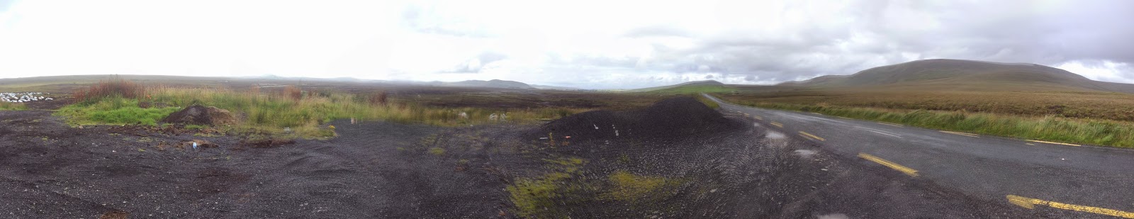
Our plans for today are to travel East along the coast of The Beara Peninsula, from Coolieragh, and then head North up to the Healy Pass and join the Ring of Beara to ride to the start of the 'Ring of Kerry'. Then head North and ride through Molls Gap, then navigate through the back roads, to the North of the Ring and then head West to check out the Cahergall Hill Fort.

Fig. 2 - Alex wonder as to my sanity, at taking a photo of an,
unusual to me, petrol pump.

We pop into Glengarriff, to look for fuel and to top up our tanks but in the end decide to carry on to the next fuel stop. We did stop briefly next to the only fuel pump in town, which I found novel, as it was mounted simply on the foot path, directly outside a shop. Albeit these where common years ago but to us ‘youngsters’ it’s a little unusual to see.

Fig. 3 - The view from the Healy Pass.
The Healy Pass turns out to be a rather exiting twisty run, I take it as easy and as smoothly as I can, being conscious that Alex is filming with his 'head cam' it and I wanted to make it at least look good. However despite this I managed to slam the bike into the tarmac, with the damn centre stand, something I thought would be a useful addition to the bike, but in practice was being more of a danger than a help, and I end up tearing a chunk out of the asphalt and leaving my mark on Ireland. When we arrive at the top of the Pass and stop to chat, Alex mentions that the impact, and how he had seen my rear wheel throw itself a foot to the left, at the time I was too busy swearing to notice. Apart from my centre stand, now giving me some paranoia of a repeated incident, we had made it smoothly to the top of the 'Healy Pass'.

The 'Healy Pass' or 'The Tim Healy Pass', was built in 1847, to help prevent starvation and in 1931 was dedicated, posthumously to 'Timothy Michael Healy'. A local politician, who appreciated the need for a proper road to exist to connect the Kerry and Cork sides of the Beara Peninsula. Another interesting though quirky fact we learned, was that during funeral processions, the coffin was pushed across the county line, to be then received by the folk, across on the other side of the border.

Fig. 4 - Photo shortly after the moving forward to remove the
white car from view.
We took the opportunity to take a few pictures, however there happened to be a White car in the way of our shots, which Alex openly bemoaned at. Unfortunately for Alex, he hadn't notice, until too late that the lady owner, was within ear shot, not 10 feet to his right. Realising his error Alex, just sat there looking straight ahead, rather uncomfortably. I move my bike forward of the car, to remove it from my view and take a few more pictures before we then quickly move on our way.

Fig. 5 - Having a short nosy down a gravel track treats us to another lovely view.
On the way to Kenmare, we ride the R574 from 'The Healy Pass' North and followed the R573 / R571 coastal road to Kenmare. We couldn’t help but pull off the road to venture down a gravel track, to a small viewing point, looking out over a small inlet.

Fig. 6 - Stopping in Kenmare, to plan our route, next to this lovely BMW R80,
Reaching Kenmare, we stop to plan our next route, parking near a nice looking White BMW R80 with sidecar. This was the start, of the 'Ring of Kerry' and we had hit holiday makers and lots of traffic, just as we were warned about by our American friend Jack, back in New Ross. So heeding his advice we decide to head North along the N71, to the start of Molls Gap, then follow the R568 heading West, leaving the B-road to follow the single track, back roads through Derrylea, Looscaunagh and along the Gallavally Road onto Derrylooseavunagh. Then we really went off the beaten track, by doing a spot of impromptu greenlaning, following a loop that Google maps showed us existed, through Gearhameen linking up with the Derrylous Caunagh road then on past Hollywood, no we didn’t get that lost, and then onto the Gap of Dunloe Road.

The road going through Gearhomeen, was a little challenging, as we came across a lot of tourists and ramblers and surprisingly a few horse and traps, seemingly carrying mostly American tourists about. I was glad that my exhaust was quiet, still I switched the engine off just to be safe, as they passed by. The horses where oblivious and didn't even seem to care or take any notice however. Unfortunately some of the ramblers acted in a similar fashion. One instance I had to practically stop, so as not to hit this stupid woman, who just stubbornly wouldn't get out of the bloody, way till the last minute. It wound me up and with a fist full, I blasted away in frustration, hopping I'd scare her a little. At the end of the road, there were two options, a gravel track to our left and a road over a bridge, to our right or back the way we came. Luckily Alex still had internet so we comparing Google maps, to what we could see on the ground and the GPS and made the decision to go left and see how far we could get in linking up this loop, that appeared on Google maps. 

I had no trouble on the KLE, moving over the loose gravel, whilst standing up on the pegs and keeping my weight forward. However Alex on the other hand, was on his BMW K75, with road tyres and hadn't a lot of control, but seemed to get on well enough, I thought. Though according to Alex he had no control, but only a wing and a prayer. We came across a gate which luckily, wasn't locked and carried on through and we eventually, linked back up with the tarmac road again.

Fig. 7 - In the 'Gap of Dunloe' and whilst taking this shot, a walking couple, kindly offer to take a few photos of us.
Fig. 8 - This must have been them, doing a test shot.
Fig. 9 - Smile!

The Gap of Dunloe road was extra challenging, not only where there twisties, as we descended but lot’s more ramblers and more horse and traps, plus their inevitable horse shit. Half way down whilst, crossing a bridge, I was taking a few shots of us when, one of the ramblers offered kindly to take our photos. We rode onto the bridge for our photos, we thanked them and wished them a good day whilst we carried on. The narrow road descended, down into a ravine with jagged rocks, made jet black by the rain, climbing to the sky on both sides of us. Luckily only one or two cars came from the opposite direction on this single track. Using the engine as a brake, as well as keeping the brakes on, whilst slowly overtaking traps and trying not to spook any horses, was a little challenging, soon the smell of nicely cooking brakes, met our nostrils.

Fig. 10 - What a great road. This is a small lake at
an intermediate level as we ride down the mountains side.
On top of that, as we neared the end of the road, there was a trench gouged out in the middle, created by the horses and thanks to the rain there was literally a river of horse shit running down it. Which covered the front of our bikes and hot engine casings so adding, to the aroma of cooked brakes was a sweet grassy hay whiff. Luckily of me I didn't lose too much control, moving across this trench, when I had to navigate around the ramblers as I had knobbly tyres fitted, but Alex had to get people to move around him, least he fall in the preverbal.

Fig. 11 - The battle with hikers plus horse and traps now complete,
it's time for a well-earned cuppa, in a cafe just to the left of shot.
If you look closely, you can see that our bike are now covered in,
putting it nicely, green smelly 'flock!'.
Finally arriving at the bottom, where there was a café, I made the decision, to have a breather and a bite to eat. Whilst gazing out of the café window another bike turns up, with a couple on, but from the opposite direction, they stay only a few minutes, then climbed back on and turn around heading back down the road. The bike was a nice and clean Adventure Bike and more than capable of doing this road. We chuckled as we thought, that he just didn't want to get it all dirty.

Fig. 12 - Aha, that would explain one or two things then!
Whilst leaving the cafe we look back up the road, to where we had come from, and spotted a road sign, that we didn’t see, as we'd obviously come from the opposite direction, that read 'that road was restricted to horses and access to accommodation and business only'. Ah, so that explains it the absence of vehicle traffic. Even with that being the case, I have to say that it was an exciting road and I would thoroughly recommend it. Just travel in the same direction we did and claim complete ignorance!

Fig. 13 - The main road,
or as it turned out not.
Fig. 14 - Our first sight of the Hill Forts.

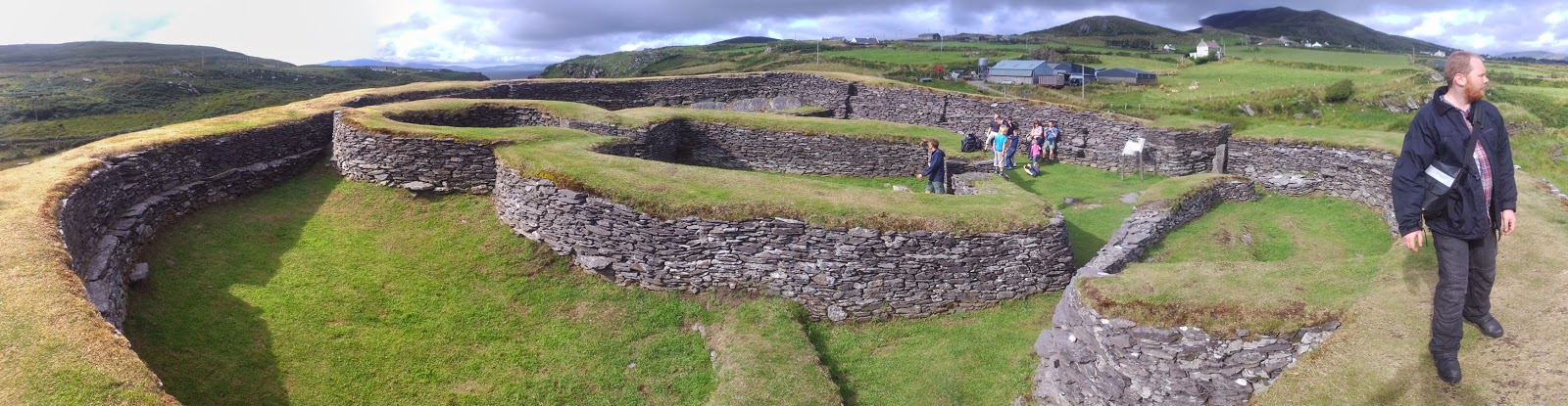
After the Gap, we turn left, following the Satnav to Cahergall Fort. We had initially chosen to go via the back roads, but changed our plans to choose to travel on the main coastal road North, following the N70, but the Satnav ignored us and took us across country. It was about half way down the road that I started to think, that the road we were on was a bit rough to be the main road, especially as Alex was spending most of his time getting air on his road bike, whilst trying to keep up with me. The road took us past Lough Acoose, through Glencer and then on over the Ballaghasheen Pass into Cahersiveen. Then, by following the tourist signs, we arrived at the Hill Fort, which we discovered to be actually two forts called Cahergall and Leacanabuile.

Fig. 15 - Approaching the entrance to Cahergall Fort.
Fig. 16 - Looking from inside back through the defendable entrance

Fig. 17 - View from the other side of Cahergall Fort.

These Irish Stone Forts are known as Cashels and there Earthen equivalent are called Raths and are both collectively known, as ringforts. High status people would have owned them, where some would have been used as defensive homesteads. They are difficult to accurately date, being rebuilt and repaired overtime, but these forts roughly date from between 500 - 800 AD and have been recently reconstructed, for the public.

Fig. 18 - Leacanabuile Fort, site plan.


Fig. 19 - Leacanabuile Fort, with Alex as a scale, thanks Alex!

The Cahergall Fort was fascinating and a real insight into some of the engineering understanding, of the peoples, who lived at that time.

Fig. 20 - View from atop Cahergall Fort, 'location, location, location'.
It was only much later on that I made the connection, with a little small fact I picked up when I visited Newgrange, was that if you see a hill that has a ring of trees growing on it, there's more than a chance, that at some time in the past there was a hill fort there, and there are hundreds dotted about Ireland.

From Cahergall Fort, we took the main coastal road East, along the N70 'Ring of Kerry', stopping halfway for some photos, looking over towards the Dingle Peninsula, which was fascinated us. Realising that we could see across the water, to where we were heading for. Using my hard copy maps, we followed the outline of the coast and soon picked out Dingle Town, we could just make out the inlet for the bay. We also decided it would be a likely place to find a hostel and about time in our journey for a decent nights rest. 

It seemed to take ages to get to Castlemaine, where we started onto the Dingle Peninsula proper and headed West towards Dingle, for the night. It was raining again, with the sky looking rather moody.

Fig. 21 - We stop, stare and listen to the sea rolling in on
Fig. 22 - Inch Beach.

A few miles along the road I spot a beach, called Inch Beach which we decide to have a ride down and onto for some photos. The sand was soft, but I had a bit more confidence in my nobblys and rode almost to the surf, before the sand became too soft me. We sat there for a minute with our engines off and just listening to the oceans surf, rolling onto the beach, as we gazed out to the horizon. It's moments like that, that are the most special to me. 


Fig. 23 - Full rainbow shot!

Fig. 24 - Got to get the bikes in somewhere.

We have to stop, again, just a mile down the road, as a rainbow suddenly appears. It  was so close you could see where one end stopped, seemingly on a grassy sand dune not far away. Quick get the shovels out again!

Moving on, we eventually arrive in Dingle and park up in the centre. I momentarily leave Alex looking after the bikes and pop into the nearest pub as the local tourist info was closed. A pub, I surmised, was as just a good an information resource as any and as it turned out there was 3 Hostels in the area. The first we visited was full but the other, The Grapevine, just a few more houses down the street, had a few beds left for us.

Fig. 25 - Our hostel for the night.
Parking the bikes on the street, opposite the hostel we, dump our stuff in our room, shared with a few others and lazily rode around the corner, to the pub for a late dinner. The food looked good, so I decided to try something local and opted for the trout, though I can’t remember what Alex went for.

We discussed plans for tomorrows ride, whilst listened to the live music that had just struck up, at which we couldn’t help but take the mick out of a little! It was good music, don't get me wrong, it was more specifically, the chap tapping a box he was sat on! It just seemed funny to us at the time that a wooded box was being used as an instrument, but why not? For a change we opted for an early night and left the pub around 10 pm.

Just before we re-entered the hostel, the sound of mixed live music caught my ears and I continued to walk just past the hostel, to the junction at the end of the street. Looking up and down and due to the fact it was Irelands main bank holiday, all the pubs and guest houses where full of life and sound. Making me somewhat regret the need for a night off, as I was sorely tempted to get involved. It’s definitely a place that gave me the feeling, that I could easily spend a few days, just soaking up the atmosphere.

DAY 14 - Thursday / Blarney Caravan Park, Blarney, Cork - Mizen Head, County Cork - Dowlings Camping Park, Glengarriff, County Cork / 132 miles


31/07/2014 / Thursday / Blarney Caravan Park, Blarney, Cork - Mizen Head, County Cork - Dowlings Camping Park, Glengarriff, County Cork / 132 miles

Thursday 10am. After looking over the map and doing some mental calculations, as a check, and decide that, I do indeed need to extend my trips end date, to complete my route. Using Alex’s phone, I call the ferry company up and extend my return date by an extra 2 days. In defence of my initial plan, If I was running at just my own pace, for the duration of the trip, the two weeks would have been just enough time.

Once packed up, I say goodbye to my friends, it feels a little sad to be leaving them, but at the same time, I can’t wait to get back to my own pace of travel. Mike gives me the next campsite location, just in case I find myself in the area that evening and want to stop in with them the night.

I plot my course into the GPS and head out, filling up with fuel at the petrol station, in Blarney next to last night’s Chinese. In fact I still have a portion, in a box strapped to the bike, for that days lunch, waste not want not!

Fig. 1 - Kinsale Harbour with the memorial to lost sailors on the right.
I ride South through Cork then onto Kinsale, stopping only briefly, for a few quick photos of the harbour. Where I stop, to take a panoramic shot, there is a decked area, with a ships mast fully rigged, erected in the centre and just to one side is a cast bronze memorial, to lost sailors.

On the way into, Kinsale I spot a couple, clearly on a short tour, as their only carrying light luggage, park up their bike. I happen to ride past them again, following the one way system, as I was trying to find a place to safely stop, and take some photos. As a biker of course you notice other bikers and both, usually acknowledge each other, but there are those times that you just get the feeling that that’s not wanted from the other party and you just ride on, this was one of those times. Funny how you observe little nuances like this.

Fig. 2 - I follow the R600 past this 11th century Cistercian Abbey.
Leaving Kinsale, I following a ‘B-road’ the R600 to Clonakilty through Timoleague, with its ruined 11th century Cistercian Abbey. Joining the N71 at Clonakilty I then turn off onto the R597, at Rosscarberry. Somewhere along this road I’m stopped, in my tracks by an arctic lorry carrying a flatbed trailer that’s loaded up with steel girders. Which, happens, just as I arrived, to of turned onto my side of the road and is now coming slowly downhill towards me, leaving me nowhere to go but with plenty of time to think over my limited options. I move forward a little and bury myself, as best I can into the hedge. As the driver passes me by, we exchange a quick chuckle and I’m left alone with the remaining 40ft of trailer to finish passing me by, with only 5 inches or clearance, from the end of my handlebars.

Fig. 3 - Glendore Harbour, on the R597.
Continuing on the R597, through Glendore, a small fishing village with a tiny harbour, where I pass a local, shouting directions at a tourist, from within her food van, which somehow makes me chuckle.

Just a few miles further on I stop, in a small village, called Leap. I was feeling hungry and remembered I had a chocolate bar on me, so stopped to fish it out. I’d just stopped on the side of the road in a small village called Leap, just before I needed to turn left on the N71, and was rooting around in my pockets, when I look up, to find right in front of me a 'motorcycle café', what great timing. I ride the few metres to park out the front, which is on a gradient, giving me a little fun parking the bike. Before I could finish, though, the owner comes out and lends me a hand. There’s another bike parked next to mine and as I walk into the café I nod to its owner.

Fig. 4 - The Motorcycle Grill, good place to fuel up.

Fig. 5 - A little Honda C50, as cafe window dressing!

I grab a really good burger, chips and a pot of tea and chat with the owner for a while, who advises me on a really good route, through the Beara Peninsular, which is apparently a better ride than its coastal road.

Fig. 6 - Just tickled me.
I take a photo of the little Honda 6v C50 he has sat in the café and a photo of the café front for my blog. Now tanked up on food, I join the N71 again, through Skibbereen, leaving on the R592, at Ballydehob. Passing through a place called 'Skull', where I couldn’t help but stop to take a photo of the ‘Skull Dental Clinic’ sign and finally turn onto the R591, to Mizen Head, stopping to take a few quick flicks of the rugged coastline and beaches along the way.

Fig. 6 - Three photos of the rugged coastline on the way to Mizen Head.

Fig. 7 - 

Fig. 8 - 
'Mizen Head' is the furthest South-West you can get to, by road in Ireland.

Arriving around midday I park up in the busy visitor’s car park, with a little walk to the information centre. There’s an 8 Euro entry fee, for what I'm not certain as I think it’s a little daft to pay to see a natural site. My main mission here, is to take a photo of my foot, at the furthest bit of concrete or tarmac you can stand on, which is something, apart from circumnavigating islands, that I like to do. The previous year I visited the furthest North-West of Scotland you can drive to and took a photo of the same foot!

Fig. 9 - Next stop from here, West, the Americas.

Fig. 10 - A treat for you, my left foot, on the furthest South-West I can place it in Ireland, well we all need a hobby.

Even with the fee, I would highly recommend this place for, the mesmerising views across to the cliffs, especially as you cross the concrete foot bridge, and look through a V-gap, through the cathedral sized rocks. It’s a geologists dream, with multiple folds in the rock strata, having been produced by some unfathomably pressures.

After you walk over the bridge, there's a slight incline, to where there are a few buildings consisting of an old signal and weather station plus a lighthouse. Walking passed these brings you to the furthest you can go, where there is a small balcony of sorts to stand on, allowing you to look down over the cliffs and out towards the Atlantic ocean.

Fig. 11 - View to the North, from the viewing platform.
Fig. 12 - View from the concrete bridge,
into the cathedral like void.

Looking over to the horizon, I couldn’t help but think that the next stop, is the Americas. There’s only enough room on the platform for one or two people, at any one time, so I quickly spent a few moments in contemplation, before making room for the next person, but not before I had them take my photo. With the feeling that I had spent enough time there, I happily head back to the bike.

Looking at the map, I felt that the campsite, Mike gave me that morning, fitted in well with my route and timings, so I plot in the Dowlings Camping Park Site, located just West of Glengerriff. I also add in two via-points following, the North side of the peninsula. I almost deciding not too in favour of a more direct route, but am so glad that I didn’t, as I was treated to some exciting roads and gorgeous views. Though towards the end I could tell I was getting a bit tired out as I had a harey few moments.

Fig. 13 - Dowlings Campsite, just West of Glengerriff.
You can just see where we have camped to the left, with the
site pub above and to the right.
Arriving at the campsite just after 6pm, I easily find where the others have pitched up, although the place was deserted. I pitch up beside their tents and settled in to catch up with my writing. Taking a little break, to ride into Glengarriff, and check out the restaurants, for any sign of the others but to no avail. So I went back and chilled out in my tent, luckily there’s a pub on site, although it didn’t open till 7:20, but as soon as it opens, I plan on ensconcing myself at the bar, to finish off my writing, whilst waiting for them to turn up.

(I write the following the morning after arriving home)

Around 8pm, I pop out of the pub to pick up my phone, I had left on charge with the campsite owner, who sat in her reception hut. Back in the pub ‘Nick’ the barman, a friendly and chatty Irishman, served me a Guinness and we passed the time of day nattering away. I remembered I was looking to get a Bodhrán, a traditional Irish skin drum and ask him where a good one might be found. Nick recommends that the best place to get a good one, from, is further North in Galway. I also mention that before this trip, I had a distinct lack of knowledge of Irish history and felt that I had to do some swatting up, before coming over. Nick suggests that I learn, about Michael Collins, who died on the 22nd August 1922. Shot in West County Cork, by the British in an ambush, as he had strongly believed he couldn’t be killed within his own county and knowing this snippet would get me along grand with folks.

A few local lads, stop in for a few jars and I soon engaged them in a bit of a chat about travel, as I overheard one of them was planning a journey on a bicycle through Thailand.

Nick, needs to nip off to run some errands and leaves the bar in the capable hands of Katy. She runs the bar for some extra cash in hand. I chat to her a bit and discover that she used to be really into her Irish dancing but is currently having a year out and greatly is missing it.

I jump onto the pubs Wi-Fi and find the others, have been uploading flicks to Facebook of their days adventures. I also find a photo of where there eating tonight. I lean over and ask the lads, showing them the photo, they tell me it’s in a village some 25 miles East, further along the coastal road. I've already had a pint, and since I don’t drink a lot, I decide its best to stay and have another rather, than chase them down.

An hour or so later I get, as I was half expecting, one of the group discovers me and tap’s me on the shoulder, its Alex. He sits down and I get him a pint in as he tells me of his day.

Alex is finding Mike and Alexa’s pace a bit slow going and decides he’s going to join me for the next few days. That's fine with me. Mike pops in and we have a brief catch up, as Alexa’s knees are causing her a lot of pain and she’s having to rest back in their tent.

Mike takes a few drinks back, with him leaving me and Alex stopping, in the pub till 1am. Fitting in a few games of pool which I consecutively win, even when I was trying to loose, so at least he could win, even just the once.

Live traditional music, is struck up around midnight, which is the first I've heard in a pub in Ireland, and it’s good. Another group of bikers touring Ireland enter the bar, and we all get chatting about our respective adventures. It turned that they were heading in the opposite direction to us and their main navigator interrogates me on the best routes and what’s good to see and likewise avoid. I return the favour, by interrogated her about their route, to get the heads up on which good roads to take and avoid. One of their group, who’s a native, cannot recommend enough that we travel through 'Joyces County', which, for himself, he usually just blast up straight there and spends a week simply criss-crossing around. 

I drift off to bed around 1pm, leaving Alex at the bar, presumably trying in vain to get the barmaids number.